Showing posts with label family picnic. Show all posts

Tuesday, 9 August 2016

Wild Swimming in Eerie England

We have been on our holiday and we managed to spend a few glorious days on Dartmoor, one of my favourite places, with a seemingly limitless array of stunning locations to walk to. This time we took a  walk North, following a branch of the Dart river, from Two Bridges to visit Wistman's Wood.
Wistman's Wood is fairy small, and yet, it is a truly spectacular place; stunted dwarf Oaks, huddle together and cling to the sides of the steep valley amidst a chaotic carnage of vast granite boulders. The curious feature that makes it seem like a set from a Harry Potter movie, is that the whole place is positively draped in dense layers of thick green spongy mosses and ferns.
You need to be careful, as you clamber through the boulders, partly because it is slippery and dangerous terrain, partly because you want to preserve this unique environment and partly because there are various legends that indicate that the Devils ghostly Wist Hounds abide in the area, as well as nests of writhing vipers. 
We found it a truly splendid place and it fulfilled my slightly obsessive quest for English Eerie. After eating our sandwiches in the Druidic grove, we trekked back over the nearby tors to the Two Bridges Hotel for tea and scones. Finally, on our route home, we stopped off at Merrivale to visit the fascinating array of stone rows and circle there.
On another day we took a lovely woodland walk from the village of Holne, again along the river Dart until we found the legendary Sharrah Pool.
This idyllic spot is perfect for a picnic followed by a bit of wild swimming. The Dart has carved out a massive groove through the ancient granite landscape, which is deep enough to dive into in several places (if you are brave enough) and longer than 100 meters. 
There are several delightful places along the river, where it is deep and accessible enough to swim, and these natural Jacuzzis are becoming more popular with the recent trend for wild swimming in the UK but Sharrah Pool is astounding and an absolute must.
The dark peaty water gushes down-hill via boulder strewn white-water rapids and sluices into the main pool via a narrow waterfall and channel, "the Sharrah Shoot". The bold can plunge into the shoot and get swept into the pool for further swimming and frolicking. After exhausting ourselves in the pool, we hiked back to Holne for the best cream teas in Devon from the local community shop, the perfect conclusion to a brilliant day out.

Thursday, 16 July 2015

Plum Picknik

Everyone is invited to a, Plum /  Cherry-Plum / Mirabelle / Bullace / Greengage - Foraging Picknik (I don't care what they are all called, as long as they taste good). 
This event will take place this Sunday morning, in Avenue Park, Stoneham. Anyone who joins us, can also take in a visit to the lovely First World War shrine in the park.
The event is suitable for families or adults. The lovely plums here are plentiful, they taste great straight off the tree and would equally be great for baking, jam, chutney, pies, wine etc.
The Usual  (Plum) Suspects
Fruit pickers are handy, if you have them, but we can share and there will be plenty within reach or on the ground. You can always hold a blanket out and shake the branch. Bring suitable containers (buckets/baskets)  if you want to take some fruit home with you. It's always nice to bring some cake to share too.
This event will go ahead regardless of the weather ;-) so dress appropriately, bring a brolly in case or just come to see where the trees are and then come back when you have time.
Venue: Meet in the Cricket Pitch Car Park (almost opposite the Cricketers pub), Chestnut Avenue, Eastleigh - mind the bollards if you're driving.
Date: Sunday 19th July - this Sunday morning.
Time: 10.00 am (plenty of time for the Sky Ride later)
Cost: It's all FREE!

N.B. This is a casual event, everyone is responsible for their own (and their children's) health & safety. 

Saturday, 6 September 2014

Mysteries of Dartmoor

No food in this post, unless you count our sandwiches, the Apples Hazelnuts and Walnuts will be ripe soon, but for now, two lovely walks... This Summer we were in Devon - and when in Devon - I always insist on visiting Dartmoor. I love to walk in the wildness of this place and I especially enjoy hunting for prehistoric Stone Circles. This year we managed to make two separate trips. Fortunately, the rings on Dartmoor have not been sanitised and fenced off, like Stonehenge. There is no visitor centre, you cannot arrive by coach, and you must scramble over rough terrain, in order to reach them.

First we marched over Whittenknowle Rocks and through the derelict Ditsworthy Warren House, before stopping to eat a picnic on a large rock. Then my intrepid son and I continued ahead, navigating our way through a bog and herd of huge cows in order to reach the ancient ritual area of Drizzlecombe.
At Drizzlecombe we explored the massive standing stones and mysterious stone rows that teem down the hillside from the remnants of a primitive settlementThe standing stones are impressive monuments and must have been very important. No one knows exactly why the rows were erected or what significance they held for the builders. Some, but by no means all, seem to be associated with burial mounds.
On our second outing, the objective was Scorhill Stone Circle, which turned out to be a popular destination. We met several other people hiking around carrying maps, and it wasn't too long before we located this fantastic ring.
Scorhill (pronounced Scorill) is a very evocative place; you could easily miss it as you dodge the ponies, cows and sheep down the rugged hillside path. However, once you arrive and spy the wonderfully jagged rocks sticking up like the fangs of some primordial monster, you know that you are in a very special place.
The sweeping panorama from this singular site is nothing short of majestic. From where we sat enjoying our sandwiches and coffee we could also see a smaller ring on a nearby hillside. The shades and tints of the landscape were stunning; the blue-grey sky against the dun horizon, purple heather mingled with the green and yellow of gorse and wild flowers.
The great granite-grey stones that form the ring stand like sentinels but what they guard, no one can know. It was very atmospheric, and I felt lucky to be there on such a stunning day. I sent the children scurrying off in opposite directions to count the stones and they predictably came back with different answers.
We spied several ancient stone clapper bridges down in the valley below us and we wandered down to explore these after eating our lunch.

Wednesday, 22 January 2014

The Devil in the Detail

The Curiously Named, Cheesefoot Head
Not much happens, in the foraging vein, during the Winter months, but we still love to get outdoors when we can.  The children and I went for a walk around Cheesefoot Head in December and had a lovely time scrambling up and down the banks and exploring the woodland.
The Devil, Recently
One place that I have always wanted to visit is the Devil’s Punchbowl. I had seen it it many times, normally when stuck in the traffic bottleneck of Hindhead on the  A3. Now though, the busy London to Portsmouth road has been diverted through a tunnel, which means that the scenic area can be returned to something like its original beauty. The landscape here is actually a valley and not a “bowl” but this fact does nothing to diminish the staggering nature of this place.
When I suggested the Devil’s Punchbowl, my daughter asked why I always took them to places with evil names - we walked to the Hell Stone in Dorset last Summer and the year before we found the Deadman's Plack. I explained that remarkable places often have curious names. To be honest, I simply love maps and enjoy walking; so I frequently gaze at Ordinance Survey maps, hunting for wicked names or stunning ancient contours, where we can have a little adventure.
There are various legends attached to the Punchbowl, including an argument between Thor and Satan; the village of Thursley (named after the Thunder God), lies nearby. It’s always good to have an ancient story to engage the nippers with on the journey and there is a conveniently grisly tale attached to the A3 at this point. This involved the murder of an unknown sailor in the 1700’s and the subsequent punishment of three perpetrators. They ended up hanging from a gibbet atop the appropriately named Hurt Hill. 
Fortunately, the grim remains have now been replaced with a granite monument and some nice laminated signs. The original engraved marker-stone still stands though, detailing where and when the crime occurred. The unfortunate sailor’s gravestone can be seen in the Thursley churchyard, if you are curious enough.
Muddy Hell!
Some friends came with us, bringing Mungo, their lovely dog. Mungo kept my son constantly entertained by enthusiastically fetching every stick he threw, and the two of them were scampering back and forth throughout. We walked a fair way around the busy edge of the “bowl”, before stopping for a picnic and finally cutting back down through the valley along a lovely quiet sandy path. The thin, Winter sun was shining on us for so much of the walk that we ended up carrying the kids coats - you would not have guessed that it was mid-January.
The final part of our journey was more challenging and involved negotiating a very steep and slippery hill, which was covered in storm smashed trees and damaged fences. There were no casualties but the dog, and everybody else, did require hot baths that night.


Thursday, 5 September 2013

Iron Age Elderberries

It was the last Bank Holiday in August and the sun was still beaming it’s joyful rays onto the parched earth. 
Get Busy With the Fizzy
We decided to go to Danebury Iron Age Hill-fort for a summer picnic. We packed our bag, sandwiches, snacks and a bottle of vigorous home - made Elderflower Champagne and set off along the Test Way.
A Big, Fat Fish in the Test River

Danebury is the perfect spot for a run about with the children, but first we sat down to feed our poor starving mites and treated ourselves to some sparkling English Fizz, with one of the best views available in Hampshire.
and Relax...
After we had eaten, I set off with my son to hunt for Elderberries, I wanted to make port again; I have done this successfully for the past 2 years. As it turned out, we filled our boots with a sufficient quantity from the first small tree we came across. You can also make Elderberry cordial, jam and many other hedgerow recipes from this eldritch provider.
Elderberries
Later, we  found plenty of Blackberries and a crop of Raspberries, which we simply scoffed, as quickly as we could pick them. We also found loads of Juniper bushes, which was something of a revelation.
Ruby Red Raspberries
Juniper berries have a three year cycle (flowers, green berries, dark-blue berries) and they can all be present on one bush at the same time. These prickly bushes are related to Pine trees and the berries are actually tiny pine-cones.  The blue berries are used as herbs or spices when dried. They have many herbal uses and are also a significant part of the flavouring used in Gin!
Juniper Bushes
Sadly, like the Ash, Juniper bushes are currently under siege by a fungus, which is threatening their existence all over the country. Let’s hope that the arboricultural experts can do something to save all these trees. I’d hate to go through Summer without a cold G&T.
Ripe Juniper Berries
At one point the peaceful background hum of the countryside was shaken by the thumping of a Merlin engine and the iconic shape of a Spitfire roared into view across the trees. When it appeared, I had been thinking about the role of hill forts during the Roman invasion; the mysterious legend of the Angels of Mons crept into my mind. The plane vanished into the distance, like a ghost from the past, leaving nothing but blue sky. Looking back, the moment was so dreamlike and anachronistic that if I hadn't photographed it, I might doubt my own memory.
A Spitfire Over Danbury?

Saturday, 8 September 2012

Stonehenge the Senic Route

It has been a long time since I visited Stonehenge; I last did it via an illegal pop festival in the boot of my friend's Ford Cortina, in the early eighties...
Back to the present day and things have changed considerably, but I didn't want to just trail the children around the stones and then go back to a hot car. I wanted to see the surrounding countryside; so I took an Ordinance Survey map.
Rambling along the route we followed allows you to understand the context of this enigmatic monument within the landscape; there are several explanatory plaques along the way. The experience of the walk will greatly augment the information you receive when you inevitably join the masses, trudging around the stones.
This is stunning, quiet (apart from the military helicopters that use the Cursus as a landmark) countryside hike of about 4 miles; my 6 year old boy managed the route, aided by a picnic roughly halfway along. You will be walking through rough fields (some containing animals) and clambering over styles, so the route may seem more like 5 miles.
Start in the hideously busy visitor centre car park (if you must) parking and toilets are free. An alternative would be to park in Amesbury near the church or set off across country from Durrington walls / Woodhenge.
Walk over the fields to view the Cursus Barrows, a few other people will manage to do this with you. We saw lots of wildlife and only a couple of other people, after we reached the CursusGo through a gate or over a fence and walk through the field to the Cursus, hardly anyone else will bother going this far but it is well worth the effort. The Cursus is marked by a slightly raised bank on either side, walk along the Cursus from West to East.
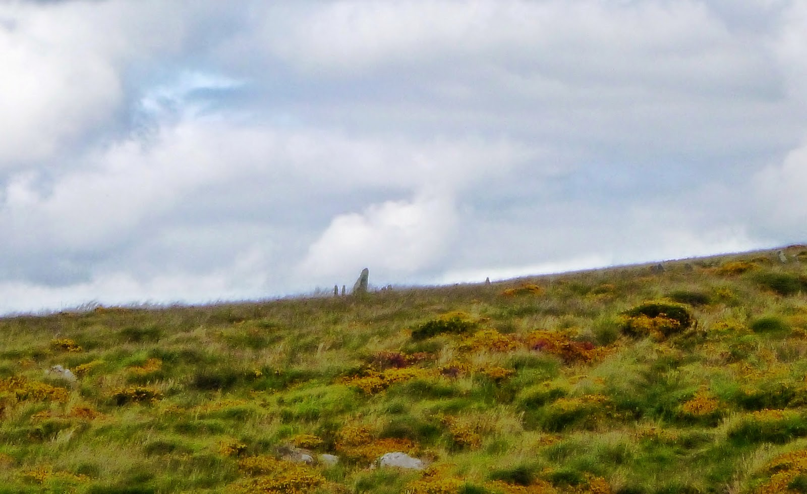
Walking the Cursus you will pass a waterworks and cross a rough road via styles; about 3/4 of the way along, Stonehenge becomes visible on the horizon, putting it into perspective within the environment. You will also notice the shimmering mass of the car/coach park and (what looks like) a caged hoard of lemmings slavishly trudging toward the Stones, shop and back to their oven-like vehicles. If you do only this, you will surely miss out on the best possible experience.
Just past the Eastern end of the Cursus, head South - down the path until you see the Old Kings Barrows on your right.
Go West now until the path turns South again to the New Kings Barrows.
Chasing Thistledown
Just before the New Kings Barrows you will see a sign indicating the Avenue, which crosses the path you are currently on, East to West.
It's well worth visiting the New Kings Barrows, which are just past this point (we had to negotiate a flock of sheep occupying the path at this point, they were no trouble), then turn back and cross the field via a gate and walk along the Avenue in a Westerly-ish direction.
The Avenue is now an overgrown cow field and rarely walked but with a map and some good observation skills, you should be able to work out your route. The Avenue turns toward the Henge roughly in line with the corner of the trees by the Eastern end of the Cursus.
You will then be walking up-hill, through sheep, toward the Heel Stone and Stonehenge monument. You will now also be walking in the same direction that the sun would shine, as it rises at dawn on the Winter Solstice.
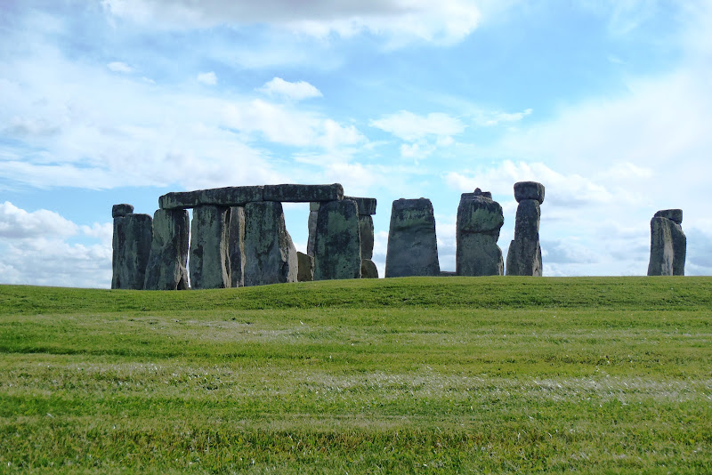
Go into the car park; there you can get yourself a well-earned cup of something or an ice cream. Finally, visit the Stones from here, along with the hordes; as you walk around the fenced off Stones; take care to look out at the various barrows, some of which you will have already experienced; they now all lie on the horizon of the various vistas, setting the iconic Stonehenge monument at the centre of this mysterious prehistoric landscape. 
It is just about possible, with careful camera positioning, to make the crowds of people vanish from your photos.
Hungry Starlings by the Cafe
Entrance to the monument is free for National Trust and English Heritage members.
The Obligatory Tourist Shot
The good news is that whole journey will soon be made far more agreeable because the visitor centre, shop and car park are going to be relocated more than a mile away and then screened by trees. The busy road and ugly 2m high chain-link fence that separates the Stones from the Cursus and the Avenue, are then going to be returned to grass.
The Rest of the Tourists
Why this was not done in the first place is almost as big a mystery as how and why Stonehenge was built in the first place!
Map of our Walk Route http://goo.gl/maps/GlviH